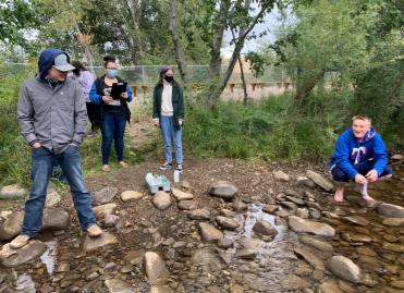
MCD’s RiverWatch Program
RiverWatch is a collaborative effort between River Sciences and Colorado Parks and Wildlife to work with volunteer water stewards who monitor local water sources’ water quality to report to the public and Colorado leadership on water conditions throughout the state. MCD collects samples of metals and nutrients at nine different sites throughout the upper and middle watershed.
We also work with the High School chemistry class to provide students with educational opportunities in STEM fields. The students spend their time with RiverWatch collecting and analyzing samples in small groups. Students are trained by MCD staff to collect water samples and learn to conduct water quality tests.
If you would like to join us for a sample collection or have us join your class; reach out to Aaron Kinsley - aaron@mancoscd.org
Mancos Watershed Data Assessment
The Mancos Conservation District contracted Lotic Hydrological to compile and analyze all collected water quality data. This data is referenced within the Mancos Watershed Stream Management Plan (MWSMP). The report aims to provide a high-level overview of stream and river conditions. Presentation of data analysis results in figures, tables, and maps intends to facilitate rapid interpretation across large geographic areas. Key takeaways regarding data availability and aquatic conditions are provided for each topic area.
See your watershed.
Mancos Watershed River Conditions Interactive Map
Explore river and lake conditions in the Mancos River Watershed , including water temperature, streamflow data, fishing access sites, closures, AIS inspection stations, and more.
MCD has monitored sections of the Mancos River to determine when and where river dry-ups occur each year. By interacting with the map you can see the locations on the Mancos River that have dried up in the past.


